No Warnings, Watches, or Advisories

AuburnWeatherLive Image
Radar image courtesy of AuburnWeatherLive.com.
spacer
METRIC | IMPERIAL
Updated: 18-May-2024 @ 9:20pm   (0 sec ago)
Temperature Current Conditions Forecast / Storm Prediction
Currently Outside: Colder 0.3°F than last hour.

53.2°F

---
High Today
56.0°F
8:53 AM
Low Today
52.4°F
5:32 AM
Yest High
70.8°F
2:07 PM
Yest Low
51.4°F
5:16 AM
Normal High
67.8°F
Normal Low
48.6°F
Sta* High
91.1°F
2017
Sta* Low
33.0°F
2023
* This Station's Records Since 1/2007
overcast -  light rain; mist overcast - light rain; mist

Wind from NE Wind:  NE
4.3

Gusting to:
1.0 mph
Current Rain Rain:
2.13 in
Chandler Burning Index: LOW Current CBI
Fire Danger:
-2.1 of 100
Tonight

Tonight: Light Rain Likely then Areas Of Fog
Light Rain Likely then Areas Of Fog
Sunday

Sunday: Chance Light Rain then Cloudy
Chance Light Rain then Cloudy
Sunday
Night
Sunday Night: Patchy Fog
Patchy Fog
Lo 51°F Hi 63°F Lo 49°F
SPC Activity Map
Dew Point Liquid Precipitation Wind Speed Sun/Moon
Current: Decreased 0.3°F since last hour. 53.2°F
Last Hour: Decreased 0.3°F since last hour. -0.3°F
High 4:50 PM: 55.0°F
Low 1:46 AM: 47.3°F
Record High: 79.2°F on
19-Aug-2021
Record Low: -28.8°F on
14-Feb-2016
Wetbulb: 53.2°F
Rain Today
rain graph

Today: 2.13 in
Storm Rain: 2.13 in
Yesterday: 0.00 in
Last 7 Days: 1.18 in
May Rain: 4.70 in
May to Date
  Avg:10
1.65 in
May to Date
  Diff from Avg:10
Over 3.05 in for the month 3.05 in
May Avg: 3.04 in
Diff from Avg: Over 1.66 in for the month 1.66 in
Season:1 25.71 in
YTD
  Avg:11
13.11 in
YTD
  Diff from Avg:11
Over 12.6 in for the year 12.60 in
Last Rain
Time/Date:
18-May-2024
at 7:21 PM
48 rain days in 2024
7 days in May
0 days since last rain
Current: NE  4.3 mph
1Hr Average: 5.7 mph
Wind Run: 109.81 miles
Wind Gust
Current: 1.0 mph
Today: 18.4 mph 8:42 PM
Month: 25.0 mph 16-May
Year: 36.0 mph 11-Mar
Record Gust: 46.0 mph
2-Mar-2021
Sunlight:
14 h 40 m 38 s
of Sunlight Yesterday
14 h 42 m 33 s
of Sunlight Today
Which is
1 min 55 sec longer than
yesterday
14 h 44 m 24 s
of Sunlight Tomorrow
(Noon ?>) graph (Midnight
Legend

Waxing Gibbous
Waxing Gibbous, 10 days, 22 hours, 7 minutes in cycle
82%
Illuminated
Humidity Barometer
Current: No Change 100%
Last Hour: No Change 0%
High 4:42 PM: 100%
Low 12:00 AM: 76%
Record High: 100%
30-Jun-2008
Record Low: 0%
22-Nov-2021
Current: Rising 0.017  inHg/hr 30.021 inHg
Last Hour: Rising slowly
High 11:47 AM: 30.038
Low 4:07 AM: 29.969
Record High: 30.859 inHg
25-Nov-2015
Record Low: 28.650 inHg
7-Feb-2020
Heating Degree Days Coming Soon Wind Chill Air
Today: 9.4
May: 176.2
2024 to Date: 3537.2
Cooling Degree Days
2024 to Date: 1.7
Current: 52.4°F
Low 5:32 AM: 52.4°F
Yesterday: 51.4°F
Record: -36.2°F
4-Feb-2023
Quality
Index6:

24


Good
Density:
1.24 kg/m3
UV Summary/Forecast Solar Summary
May-18

6.9
May-19

7.7
May-20

7.9
Sunrise is at: 5:21 am
Solar Noon: 12:43
Sunset is at: 8:05 pm
Almanac Snow3 Station All Time Records Cloud Level
Currently: Evening
YTD Avg Temp: 39.5°F
Sunrise: 5:21 am
Sunset: 8:05 pm
Moonrise: 4:24 pm
Moonset: 3:20 am
Full Moon: 23-May-2024
New Moon: 12:38 UTC
06-Jun-2024
Today: 0.00 in
Yesterday: 0.00 in
May Snow: No Change 0.00 in
May Avg: 0.00 in
Diff from Avg: 0.00 in
Season Total:2 36.00 in
Snow Depth: 0.00 in
0 snow day in May
8 snow days this season.2
HIGHS: LOWS:
96.8°F
22-Jul-2011
-14.6°F
14-Feb-2016
Daytime Records
  91.0°F°F
01-Jul-2018
  -2.6°F°F
21-Jan-2019
Nitetime Records
  82.9°F°F
07-Jul-2010
  -8.7°F°F
14-Feb-2016
ICN:15 | S3C2:0 | Ajax 3.xx
ISS:Ok | CON:4.2 | RCP:99%
1 Rain season: Jan 1st to Dec 31st.   2 Snow season July 1st to June 30th.   3 Snow manually measured usually around 7AM and 7PM.   6 Air Quality Index is provided by Minnesota Polution Control Agency and is updated hourly between the hours of 6AM and Midnight.   10 Historical average only to day 18 of just the month of May for this station since 2007.   11 Historical average rain this season to day 18 of May for this station since 2007.
 NWS Weather Forecast  -   Outlook Tonight & Sunday
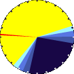
Tonight

Tonight: Light Rain Likely then Areas Of Fog
Light Rain Likely then Areas Of Fog

Lo 51°F
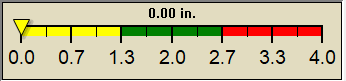
NWS forecast: Rain likely and areas of fog before 9pm, then areas of fog and a chance of rain. Cloudy, with a low around 51. Northeast wind around 8 mph. Chance of precipitation is 60%. New rainfall amounts less than a tenth of an inch possible.
Local station forecast: Increasing clouds with little temp change, precipitation possible within 24 to 48 hrs.
Sunday

Sunday: Chance Light Rain then Cloudy
Chance Light Rain then Cloudy

Hi 63°F
NWS forecast: A chance of rain and patchy fog before 9am, then patchy fog and a slight chance of rain between 9am and noon. Cloudy, with a high near 63. Northeast wind around 9 mph. Chance of precipitation is 30%.
 NWS Short Term Weather Forecast
Sunday
Night
Sunday Night: Patchy Fog
Patchy Fog
Monday

Monday: Patchy Fog then Partly Sunny
Patchy Fog then Partly Sunny
Monday
Night
Monday Night: Mostly Clear
Mostly Clear
Tuesday

Tuesday: Sunny
Sunny
Tuesday
Night
Tuesday Night: Mostly Clear
Mostly Clear
Wednesday

Wednesday: Sunny
Sunny
Wednesday
Night
Wednesday Night: Partly Cloudy
Partly Cloudy
Lo 49°F Hi 76°F Lo 53°F Hi 84°F Lo 58°F Hi 86°F Lo 60°F
ajax-dashboard6.php - Version 6.95h - 20-Feb-2023 - Script by: Scott of BurnsvilleWeatherLIVE.com
Now supported by Saratoga-weather.org Download